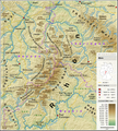
File:Eifel - Deutsche Mittelgebirge, Serie A-de.png

本预览的尺寸:576 × 599像素。 其他分辨率:231 × 240像素 | 462 × 480像素 | 738 × 768像素 | 985 × 1,024像素 | 2,500 × 2,600像素。
原始文件 (2,500 × 2,600像素,文件大小:9.83 MB,MIME类型:image/png)
文件历史
点击某个日期/时间查看对应时刻的文件。
| 日期/时间 | 缩略图 | 大小 | 用户 | 备注 | |
|---|---|---|---|---|---|
| 当前 | 2017年5月13日 (六) 10:53 |  | 2,500 × 2,600(9.83 MB) | Thoroe | Brohlbach (Mosel) korr. |
| 2017年5月10日 (三) 23:05 |  | 2,500 × 2,600(9.82 MB) | Thoroe | + Stadtkyll | |
| 2017年5月7日 (日) 13:56 |  | 2,500 × 2,600(9.82 MB) | Thoroe | 1st revision | |
| 2017年5月4日 (四) 20:37 |  | 2,500 × 2,600(9.82 MB) | Thoroe | {{Information |Description ={{en|1=Topographic map of the Eifel}} {{de|1=Topografische Karte der Eifel}} |Source ={{Own using}} *[http://gmt.soest.hawaii.edu Generic Mapping Tools (GMT)] with [http://dds.cr.usgs.g... |
文件用途
以下页面使用本文件:
全域文件用途
以下其他wiki使用此文件:
- arz.wikipedia.org上的用途
- bn.wikipedia.org上的用途
- ca.wikipedia.org上的用途
- da.wikipedia.org上的用途
- de.wikipedia.org上的用途
- Eifel
- Vulkaneifel
- Wittlicher Senke
- Winterspelt (Andersch)
- Schneifel
- Östliche Hocheifel
- Ahrgebirge
- Rureifel
- Nordeifel
- Südeifel
- Zitterwald
- Portal:Eifel
- Kermeter
- Hürtgenwald (Forst)
- Wikipedia:Kartenwerkstatt/Kartenwünsche
- Moseleifel
- Liste von Bergen und Erhebungen der Eifel
- Voreifel
- Liste der naturräumlichen Einheiten in Rheinland-Pfalz
- Benutzer:Thoroe
- Bitburger Gutland
- Wikipedia:Kartenwerkstatt/Archiv/2017-05
- Prümscheid (Naturraum)
- Benutzer:Thoroe/Making of Thüringer Wald
- de.wiktionary.org上的用途
- el.wikipedia.org上的用途
- en.wikipedia.org上的用途
- en.wikivoyage.org上的用途
- eo.wikipedia.org上的用途
- es.wikipedia.org上的用途
- et.wikipedia.org上的用途
- fa.wikipedia.org上的用途
- fi.wikipedia.org上的用途
- frr.wikipedia.org上的用途
- fr.wikipedia.org上的用途
查看此文件的更多全域用途。


