File:Pearl River Delta Area.png

預覽大小:750 × 600 像素。 其他解析度:300 × 240 像素 | 600 × 480 像素 | 1,000 × 800 像素。
原始檔案 (1,000 × 800 像素,檔案大小:182 KB,MIME 類型:image/png)
摘要
| 描述 |
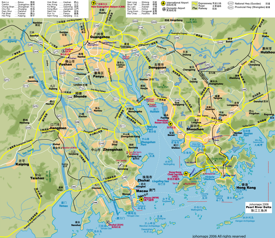
Pearl River Delta — eastern portion, in Guangdong Province.
Map drawn in October 2007 using various sources, mainly : |
| 日期 | |
| 來源 | 自己的作品 |
| 作者 | Croquant |
授權條款
我,本作品的著作權持有者,決定用以下授權條款發佈本作品:
此檔案採用創用CC 姓名標示 3.0 未在地化版本授權條款。
- 您可以自由:
- 分享 – 複製、發佈和傳播本作品
- 重新修改 – 創作演繹作品
- 惟需遵照下列條件:
- 姓名標示 – 您必須指名出正確的製作者,和提供授權條款的連結,以及表示是否有對內容上做出變更。您可以用任何合理的方式來行動,但不得以任何方式表明授權條款是對您許可或是由您所使用。
檔案歷史
點選日期/時間以檢視該時間的檔案版本。
| 日期/時間 | 縮圖 | 尺寸 | 使用者 | 備註 | |
|---|---|---|---|---|---|
| 目前 | 2007年10月11日 (四) 19:38 | | 1,000 × 800(182 KB) | Croquant | lighter color for Province name |
| 2007年10月11日 (四) 19:05 |  | 1,000 × 800(186 KB) | Croquant | Pearl River Chinese name updated | |
| 2007年10月11日 (四) 18:57 |  | 1,000 × 800(185 KB) | Croquant | Province and River names | |
| 2007年10月11日 (四) 16:54 |  | 1,000 × 800(167 KB) | Croquant | edition Jiangmen Prefecture | |
| 2007年10月11日 (四) 15:44 |  | 1,000 × 800(152 KB) | Croquant | == Summary == {{Information |Description=Pearl River Delta area, showing boundaries of the Special Administrative Regions of Honk Kong and Macau, and the bordering Guangdong Prefectures Map drawn in october 2007 using various sources, mainly : * [http:// |
檔案用途
全域檔案使用狀況
以下其他 wiki 使用了這個檔案:
- af.wikipedia.org 的使用狀況
- ar.wikipedia.org 的使用狀況
- ast.wikipedia.org 的使用狀況
- az.wikipedia.org 的使用狀況
- ba.wikipedia.org 的使用狀況
- bn.wikipedia.org 的使用狀況
- ca.wikipedia.org 的使用狀況
- da.wikipedia.org 的使用狀況
- de.wikipedia.org 的使用狀況
- en.wikipedia.org 的使用狀況
- Geography of Hong Kong
- User talk:Badagnani/Archive 10
- Talk:Hong Kong/Archive 8
- Wikipedia:WikiProject China/Pearl River Delta workgroup
- Template:User Pearl River Delta WG
- Wikipedia:Graphics Lab/Map workshop/Archive/Sep 2018
- Wikipedia:Userboxes/WikiProjects/alphabetical/22
- Wikipedia:Userboxes/WikiProjects/Regional/08
- en.wikivoyage.org 的使用狀況
- eo.wikipedia.org 的使用狀況
- es.wikipedia.org 的使用狀況
- et.wikipedia.org 的使用狀況
- eu.wikipedia.org 的使用狀況
- fr.wikipedia.org 的使用狀況
- fr.wiktionary.org 的使用狀況
檢視此檔案的更多全域使用狀況。